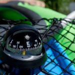
A compass is an essential tool for sea kayaking or expeditions. This article will help you choose the right compass for your paddling adventures.
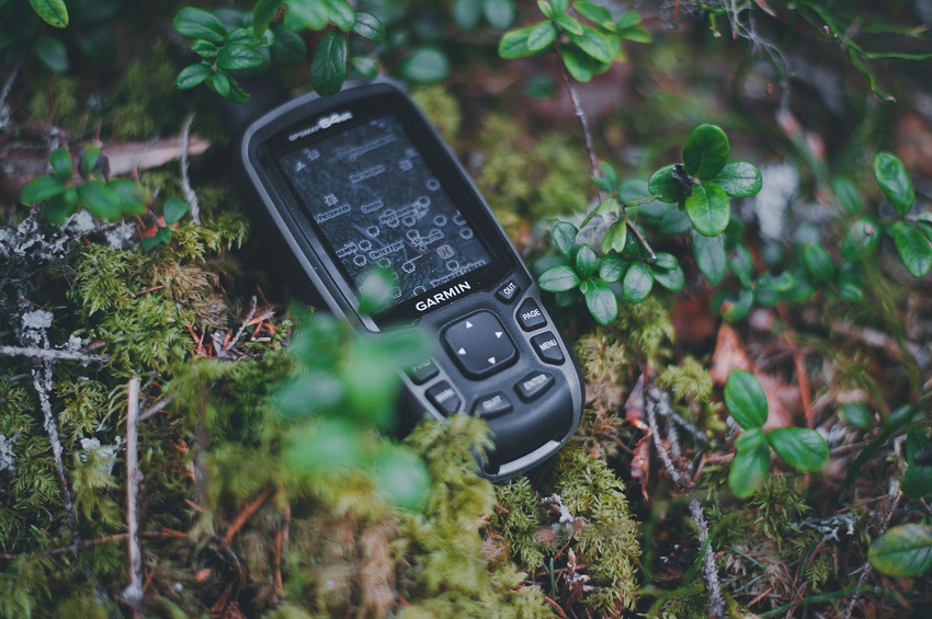
Below, we’ve compiled a list of the best GPS devices you can take kayaking, chosen specifically for their functionality, versatility, reliability, and, most important of all, waterproofing.
Contents
show
Kayaking is about so much more than just circling a calm lake or enjoying a leisurely paddle along the coastline.
With the right kayak and a healthy dose of the adventuring spirit, there are no limits to what you can do!
You can paddle out to a remote island far offshore. You can head upstream and see the source of the lake or river for yourself. You can tackle rapids and fast currents. You can meander through forests untouched by human hands, seen only by those brave few who venture along the waterways.
That’s what kayaking can be all about!
But in order to safely (key word there) venture out on these exploring trips, you need a way to navigate—to find your way back to civilization.
And that’s where a GPS device comes in handy. With the ability to immediately identify your current location at any time, anywhere around the world, you can safely enjoy your paddling adventure, be it crossing the ocean or exploring a network of rivers and streams.
Finding the right kayak GPS device can be easier said than done—which is why we’re here to help.
Check out our list of the best kayak GPS units below, and make sure to read the full buying guide to learn everything you need to know about the best kayak GPS devices for your next adventures!
As an affiliate of Amazon and other retailers, we may earn a small commission when you buy via our links, at no additional cost to you. Thank you!
Quick Answer: The Best Kayak GPS Devices
- Best Overall: Garmin GPSMAP 66i
- Best Wearable: Garmin Instinct Solar
- Best Budget: Garmin eTrex 10 Worldwide Handheld GPS Navigator
- Best for Staying in Touch: Garmin inReach Explorer+
- Best for Ocean Kayaking: Garmin GPSMAP 78sc
- Most Durable: Garmin eTrex 22x
- Best Compact: Garmin Foretrex 401 Waterproof Hiking GPS
- Best for Fishing: Lowrance Hook Reveal 7 with Tripleshot
WHY TRUST US: Here at Paddlingspace.com, we spend more time on the water than we do in the office. We paddle, kayak fish, and camp as often as we can, so we know exactly what kayakers and kayak anglers need. Each year, we independently research, review, and rate the best kayaks, canoes, and paddling gear. Our experts analyze hundreds of products to find out key differences, pros, and cons of each product. We only make money from ads or if you purchase through our links. No sponsored posts or biased reviews here, period.
Best Kayak GPS
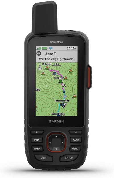
Best Overall: Garmin GPSMAP 66i
Type: Handheld
Dimensions: 6.4 x 2.6 x 1.4 inches
Weight: 1.28 ounces
Battery Life: 35 hours in 10-minute tracking mode, 200 hours in Expedition mode
If you’re looking for the perfect blend of quality, durability, and versatility, this Garmin GPS device is just the thing for you. Small enough to fit in your hand comfortably, it weighs just 1.28 ounces and will fit in any backpack, pocket, or pouch.
The GPS device is compatible with both GLONASS and Galileo. It has 16 GB of built-in memory to store A LOT of maps (including large topographical maps, accessible via TopoActive).
The GPSMAP 66i comes with the ability to download BirdsEye satellite imagery straight to your device without the need for a subscription, giving you access to all the maps you could want. You can use it to set up to 20,000 waypoints and favorite locations, chart up to 250 gpx tracks, and 300 fitness activities.
The screen is surprisingly large for such a small device, with a 240 x 400 pixel resolution that makes it easy to read the minute details on your maps. Thanks to Garmin’s optional inReach satellite service (starting at $15 per month), you have access to weather forecasts, two-way text messaging, location tracking services, and if you’re ever in trouble, just trigger the SOS and you’ll be connected to around-the-clock search and rescue services. The inReach service offers 100% global coverage, so anywhere you go, you can trust you’ll stay connected and safe.
Best of all, it’s got a very long battery life—a whopping 35 hours—and is durable enough to keep up with even the most intense kayaking trip!
If you don’t need satellite communication, check out Garmin GPSMAP 66sr. It features an improved multi-satellite, multi-band positioning technology that pinpoints your location reliably, even in challenging environments. It’s also about $100 cheaper than the 66i version.
Pros:
- Sturdy and reliable
- Includes access to BirdsEye satellite imagery, no subscription needed
- Sizeable and highly detailed screen
- Works as a cellphone
- Lightweight and compact
Cons:
- Won’t clip onto your backpack or PFD
- Software/OS is buggy, prone to crashing
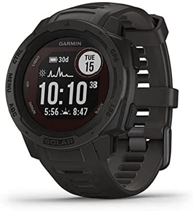
Best Wearable: Garmin Instinct Solar
Type: Wearable
Dimensions: 1.77 x 1.77 x 0.6 inches
Weight: 5.61 ounces
Battery Life: Virtually unlimited (in Battery Saver mode) if exposed to the sunlight
For anyone who wants hands-free GPS tracking, Garmin’s smartwatches are a game-changing option. The Instinct Solar combines quality GPS software with solar-charging capabilities that prolong battery life.
The watch is waterproof up to 100 meters deep, built to U.S. military standards, and is both thermal and shock-resistant. It features all the usual fitness-tracking capabilities (heart rate, pulse oximeter, activity tracking, calorie count, sleep monitor, and more), along with access to GPS, GLONASS, and Galileo, as well as a barometric altimeter and 3-axis compass.
In addition to being feature-rich, it’s also one of the most reliable and sturdy of the Garmin watches, perfect for not only kayaking, but also swimming, diving, motorbiking, and mountain biking. Take it anywhere and trust you’ll always stay connected and in control of your destination thanks to its GPS capabilities.
Pros:
- Rugged and versatile fitness tracker with smartwatch and GPS capabilities
- Thermal, shock, and water-resistant
- Fitness and wellness-tracking features
- Highly reliable
Cons:
- Plastic body
- On the pricier side for a fitness tracker
- Small screen makes it hard to read GPS tracks
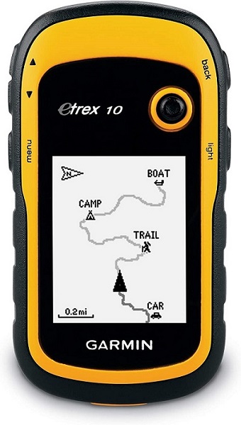
Type: Handheld
Dimensions: 2.13 x 1.3 x 4.06 inches
Weight: 5 ounces
Battery Life: Up to 25 hours on two AA batteries
Want to keep it cheap? Go with the Garmin eTrex 10! This little device is incredibly budget-friendly—costing a fraction of what you’d pay for some of the premium models on our list—but still comes with enough built-in capabilities to be a useful companion on your paddling trips.
The handheld navigator is built to be rugged, with a sturdy shell and textured grip that will be easy to hold even when your hands are wet. It’s also got pretty great battery life, running for up to 25 hours on a single pair of AA batteries. It’s also IPX7 waterproof rated and protected against rain, splashes, and capsizing.
As for its GPS capabilities, it’s WAAS enabled and comes with both HotFix and GLONASS support. The 2.2-inch display is on the smaller side and displays your maps only in monochrome, so it’s far from the most advanced GPS device. However, it allows you to set waypoints, track your routes, and even monitor elevation using the simple topographic maps included. For the price, you just can’t beat it!
Pros:
- AA battery power makes it easy to keep charged—just bring a few extra pairs in your gear!
- Compact, lightweight, and sturdy
- Budget-friendly
- WAAS-enabled, includes HotFix and GLONASS support
- IPX7 waterproof
Cons:
- Can’t clip onto your backpack or PFD
- Monochrome screen isn’t very detailed
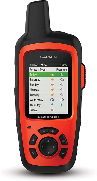
Best for Staying in Touch: Garmin inReach Explorer+
Type: Handheld
Dimensions: 1.5 x 2.7 x 6.5 inches
Weight: 0.50 lbs
Battery Life: 30 hours
Heading out on a paddling trip with a group of buddies or as a family? Or just want to make sure people back home know where you are? Use this GPS device to make it easy to stay in touch with everyone at all times. You can send real-time updates on your location with the press of a button, enabling people to track your movements no matter how far out to sea or downriver you go. In case of an emergency, you can trigger the built-in SOS to let the around-the-clock search and rescue services know you need help.
The built-in rechargeable lithium-ion battery gives you up to 30 hours of run time, and is small enough it can be easily charged using an external solar power charger or battery pack. In preparation for your trip, connect it to your mobile phone and download all the free maps you want via Earthmate. You have full access to color aerial imagery and U.S. NOAA charts, making it easy to plot the best course given the current weather and terrain conditions.
Thanks to the inReach Explorer+ app, you can access pre-loaded topographical maps and set routes to make your trip even easier. Plus, you’ve got a barometric altimeter, accelerometer, and digital compass to keep you always on track.
Note: If you love Garmin’s inReach capabilities but don’t really need navigation, try the Garmin Explorer Mini 2. It’s got all the satellite communication functions of the full-sized model but comes in half the size and sells for 60% of the retail price.
Pros:
- Features include two-way messaging, tracking/location-sharing, global interactive SOS, and built-in navigation tools
- Includes pre-loaded topographic maps, plus access to more via Earthmate
- Easy to set and follow navigational waypoints and routes
- Cloud-storage included, great for trip planning ahead of time
- 100% global satellite coverage
Cons:
- User interface isn’t intuitive or user-friendly
- Poor customer service/technical support
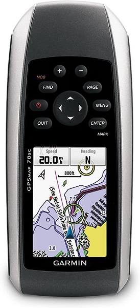
Best for Ocean Kayaking: Garmin GPSMAP 78sc Waterproof Marine GPS and Chartplotter
Type: Handheld (wrist strap is included)
Dimensions: 2.6 x 1.2 x 6 inches
Weight: 7.7 ounces
Battery Life: 20 hours
If you’re headed out to sea, you’ll want this little GPS device on board your kayak! Built specifically for marine use, it’s got a waterproof rating of IPX7 (submersible up to 100 meters), floats on the water in case you drop it overboard, and features all the maps and charts you could want for the coastal waters not only around the U.S. and Bahamas, but nearly every other sea or ocean around the world. The charts include everything from nav-aids to depth contours, shorelines to the locations of harbors and marinas. Essentially, it’s the perfect ocean-voyaging GPS device.
With this device, you can share your location and routes with friends/family back on dry land, making it easy for them to track your progress at sea and send emergency help if needed. You can also use it to pinpoint your new favorite fishing spot and invite your buddies to meet you on that off-shore island.
It’s a highly sensitive GPS device, with HotFix and WAAS enabled, accurate even when under heavy cover or navigating deep canyons. The built-in SD card slot makes it easy to expand memory to store more maps, but it’s protected against water so you will never have to worry about it getting wet.
Pros:
- Designed for ocean/marine use—waterproof to the MAX
- Great for use in nearly any ocean or sea around the world
- Includes compass, altimeter, geocaching, and location tracking
- Reliable and user-friendly
Cons:
- Poor customer service/tech support
- Lacking more robust water-based routing features
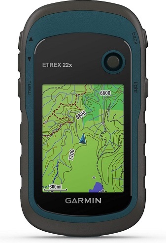
Most Durable: Garmin eTrex 22x
Type: Handheld
Dimensions: 2.1 x 4 x 1.3 in
Weight: 5 ounces
Battery Life: 25 hours on two AA batteries
This little handheld GPS device is built to survive in even the worst conditions. Rainstorms, capsizing, dust storms—you name it, it can handle it. The rugged exterior is drop- and impact-resistant, with a textured grip that makes it easy to hold even when your hands or gloves are wet. Thanks to its waterproof design, you can take it paddling anywhere and trust that it will weather the adventure.
It’s compatible with GLONASS as well as GPS, allows you to use BirdsEye (with a paid subscription) to download additional maps, and has a bright, well-sized color display that is easily visible in both dark and bright environments. Not only does it include 8 GB of internal memory, but it comes with an SD card slot to let you expand its storage capacity.
Sadly, it’s such a popular model that it often sells out or is unavailable either through Garmin, Amazon, or other retailers.
Pros:
- The most rugged and long-lasting of the GPS devices on our list
- Bright, well-sized color display makes reading maps easy
- Decent battery life, great ergonomic design
- Extensive map support—TOPO 24K, City Navigator NT, and BirdsEye
Cons:
- Often sold out/unavailable
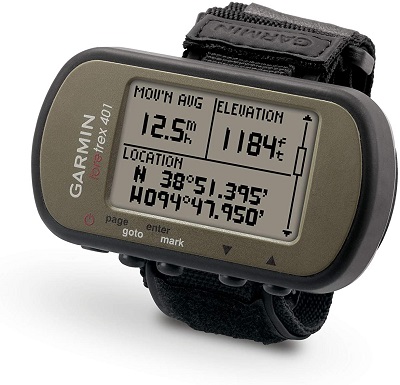
Best Compact: Garmin Foretrex 401 Waterproof Hiking GPS
Type: Wearable and handheld (dual design)
Dimensions: 1.7 x 0.9 x 2.9 inches
Weight: 3.1 ounces
Battery Life: 17 hours
This little GPS device strikes the perfect balance between wearable comfort and handheld versatility and durability. It’s built with a strap you can wear around your wrist or strap to your PFD, but the device is sizeable enough to accommodate a 1.4 x 0.9-inch, 100 x 64 pixel LCD display. Not only does it include your standard GPS functionality, but it’s also HotFix enabled to ensure maximum sensitivity and the most reliable connection possible.
The device makes it easy to track routes and plot waypoints, and it’s compatible with fitness tracking devices (such as a heart rate monitor, though that’s sold separately). Running on AAA battery power, you get up to 17 hours of run time. The onboard trip computer will log your route, distance, and time, making it easy to see your progress on the go. If you ever need to retrace your steps, the TracBack feature will help you find your way back to civilization.
Thanks to its integrated compass, altimeter, and access to sunrise/sunset times and hunting and fishing information, it’s a beautifully versatile GPS device you can use on every adventure.
Pros:
- Runs on AAA batteries (easy to pack extras when you run out of power)
- Can be used both handheld and worn on your wrist/forearm or strapped to your PFD
- Highly visible, well-sized LCD display
- Feature-rich for its small size; HotFix enabled
Cons:
- No access to maps, only GPS coordinates
- Often sells out/is unavailable
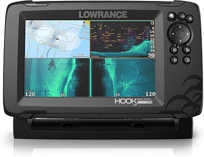
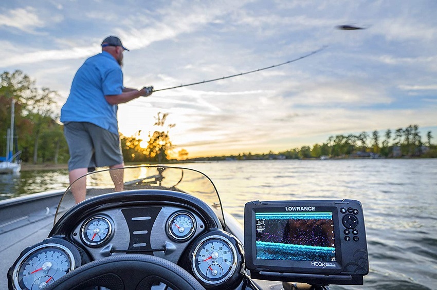
Best for Fishing: Lowrance Hook Reveal 7 with Tripleshot
Type: Mounted
Dimensions: 10.12 x 7.76 x 8.86 inches
Weight: 4.45 pounds
Battery Life: None, has to be connected to external power source
With this GPS device on board, you’ll always know not only where you are, but where the fish are, too! That’s right, in addition to detailed maps of more than 4,000 US inland lakes and the entire US coastline, this GPS device features CHIRP (sonar) that will help you locate and identify fish. The DownScan imaging will displaying high-resolution images of the water around you, highlighting fish so you know exactly where to cast your line.
The sonar is auto-tuned, meaning it will adjust on its own to adapt to the changing conditions around you. Thanks to the 7-inch SolarMax display, you can see everything in glorious detail even in bright sunlight.
Sure, it has to be mounted to an external battery (like a trolling motor battery) to function, and it’s the priciest GPS device on our list, but if you’re a kayak angler, you’ll be glad to pay the extra money to get a game-changing, fish-finding GPS navigator.
Pros:
- Crisp, colorful, high-definition 7-inch screen
- Wide-angle high CHIRP sonar maximizes fish-finding capabilities
- DownScan snaps images of fish and displays them on the screen
- High-detail inland maps of more than 4,000 US lakes
Cons:
- It’s only useful if you have an external battery on board (such as trolling motor battery)
- Pricey
Why Do I Need a GPS? Won’t My Smartphone Suffice?
This is probably the single most common question people ask when considering a kayak GPS.
The truth is that smartphones have advanced to such a degree that they now have built-in GPS capabilities. Apps like Strava, Runkeeper, All Trails, Snapchat, and even Google Maps feature GPS positioning that lets you instantly see your location at a glance. Wherever you are, whatever you’re doing, you can use your smartphone to track yourself.
Sounds like it should be the solution you need, right? With a smartphone, why would you even consider a GPS device when you’ve got GPS built right into your phone?
Well, there are actually a few very good—and very simple—reasons you need GPS for kayaking in addition to your cellphone.
Durability – Smartphones are designed to be sleek, stylish, ultra-functional devices. What they’re not designed for, though, is surviving the rough-and-rugged life of the great outdoors. Oh sure, you can buy really cool cases to protect the phone, but at the end of the day, it’s a piece of delicate electronic equipment that is going to be damaged if you drop it, fall on it, or drop it in water (a very real possibility when kayaking).
Dedicated GPS devices, on the other hand, are built for durability. They’re tough, waterproof, and able to withstand drops and falls. They’re the smart, rugged solution purpose-built for your kayaking adventures, be it crossing the ocean, daring rapids, or paddling up/downstream.
Price – How much did you spend on your last smartphone? If you’ve got one of the newer, high-end phones, that amount is probably fairly high. Are you willing to risk losing your investment if your phone gets lost or damaged?
GPS devices are way cheaper than a smartphone. You’ll pay a fraction of what you’d spend on a smartphone, and though it’s not as functional elsewhere or for other parts of your life, you can trust that it’s tough and able to survive your kayaking adventures. It’s a small investment to protect the bigger investment of your smartphone.
Charts and Maps – Google, Apple, and the programmers of other smartphone apps have done an amazing job of incorporating the most accurate data available into their devices. However, because navigation isn’t their primary focus, they may not have the latest, updated maps. Things like currents, terrain, river flows, and coastlines can change from week to week or even day to day, and if you’re not guided by an up-to-date map, you could find yourself in real trouble.
Most GPS devices are designed to access the latest topographical maps collected by the U.S. Department of Defense’s satellite system. It’s the most accurate and up-to-date source of information available, so you can always trust it will get you where you need to go.
Pretty clear, isn’t it, that a GPS device is worth the investment even though you already have a smartphone? For your kayaking trips, it’s better to have a purpose-built, durable, waterproof, highly accurate device that does exactly what you need it to—all the better to keep you safe!
A few things that kayaking GPS devices can do for you include:
- Help you monitor your paddling performance (speed, time, distance, etc.) to improve your technique and increase your stamina
- Plan your trip, manually setting waypoints to rest, camp, or portage
- Stay on course even in the dark, stormy weather, or thick fog (don’t forget about kayak lights)
- Coordinate your trip with people back at home, so they’ll always have a way of knowing where you are or where you should be
- Mark special points of interest or dangerous locales to avoid later/on your next trip/on the way back
Kayak GPS Buying Guide: Factors to Consider
GPS Unit Design
Kayak GPS devices come in one of three designs:
Mounted GPS Units
Mounted GPS devices are basically smaller, battery-powered versions of the GPS consoles used by fishing boats and larger ships. They’re designed to be connected to your kayak via a mounting system (universal or specific to the console) and feature a larger screen that displays the GPS maps clearly for you to mark your location.
No surprise, they’re the priciest of the GPS devices and require specialized mounts. However, they are also the easiest for accurate navigation because of their display size.
Handheld GPS Units
Handheld GPS devices are like small cellphones, but the really old kind with small screens (yeah, I’m looking at you, Nokia 3310!). They’re typically built to be waterproof and rugged, usually with some form of rubber or synthetic rubber protection around the plastic casing that increases both its durability and your ability to grip it even with wet hands. They’re usually stored in a pocket or pack, though many feature clip rings or include lanyards that let you wear them around your neck or attached to your PFD. Their display is smaller than a mounted device, but they’re still incredibly versatile. Some even include built-in satellite phones or two-way radios!
Wearable GPS Units
Wearable GPS devices are basically GPS “smartwatches”. They’re designed with the usual heart rate and fitness tracking software, but also feature built-in GPS functionality, including access to GPS maps. They’re not the toughest, but because they’re worn on your wrist, they’re not likely to get dropped, banged around, or fall into the water. Their small screens do make them a bit more difficult to use for GPS navigation, though.
Coverage: it’s not just GPS
Coverage is always a factor to consider when you’re thinking about a GPS device. After all, you’re likely only using one when you’re heading offshore or out into the wilds—ergo, the places where you won’t have cellphone coverage.
There are five satellite positioning systems available around the world:
GPS
GPS is the U.S.-based system, maintained and made accessible by the U.S. Department of Defense. Not only is it the oldest system of its kind, but it’s also one the most accurate. 31 satellites featuring rubidium clocks provide data directly to your device, anywhere in North America.
GLONASS
GLONASS is a Russian system, created only a few years after GPS. It’s typically available only in and around Russia (including the Pacific Ocean), but its coverage may extend far enough that you have access to it in various places around North America.
Galileo
Galileo is the European version, and it’s compatible with both GPS and GLONASS-enabled devices. It’s more accurate at higher latitudes, using 24 satellites in six orbital planes to provide widespread coverage.
QZSS
QZSS is a Japanese satellite system that doesn’t require the onboard atomic clocks required by the three primary systems. Though it doesn’t offer the same extensive coverage as the others, it’s one of the most stable and precise in the world.
BeiDou
BeiDou is the Chinese satellite system that was created as an alternative to the Russian, American, and European systems. Though its launch is still taking place in stages, when it’s fully deployed, it’s intended to be accurate down to a millimeter.
Typically, most GPS devices you’ll buy in North America and Europe have access to GPS, GLONASS, and Galileo. GPS devices manufactured in China will typically use BeiDou, though they may also access the other three networks. Similarly, Japanese-made GPS devices will operate using QZSS as well as GPS, GLONASS, and Galileo.
When shopping for a GPS device, you want to choose one that is compatible with as many satellite systems as possible. That way, you get maximum coverage anywhere in the world you travel for your kayaking adventures!
WAAS
WAAS stands for “Wide Area Augmentation System”, a specialized system designed by the FAA to increase the reliability and accuracy of GPS.
Essentially, WAAS uses a network of ground-based stations to take readings and measurements to give you the most accurate data possible—especially in the middle of storms or other adverse weather conditions.
WAAS only exists in the Western Hemisphere, though, and typically is only integrated into US-built GPS devices.
Accuracy
Accuracy is important when navigating the great outdoors!
Think about it: if your GPS device isn’t accurate, you could end up taking a wrong turn down a river, or you could veer far enough off-course on your ocean voyage that you get swept up by a dangerous current or washed out to sea.
Yeah, that’s not at ALL a good thing.
Granted, most GPS systems are designed to be accurate down to minute measurements—such as down to the meter, yard, foot, inch, centimeter, or even millimeter. With the accuracy of this degree, you don’t really have to worry too much about getting sent off-course unless you’re navigating treacherous currents or paddling rocky coastlines in the dark.
Battery Life
With any device you take kayaking, battery life is a huge concern, simply because there’s no easy way to recharge.
(Unless you’ve got the money to buy some kind of kayak-mounted solar panel.)
A kayak GPS without any battery is basically just a brick of plastic taking up space in your pack/gear, so you’ve got to make sure the device has battery life enough to last for either your entire trip, or until you can get somewhere to charge it.
Always—and I do mean, ALWAYS—read reviews and study the specs of any GPS device to make sure the battery life is sufficient to stay powered and active for the entire duration of your paddling trip.
Internal Memory
Internal memory storage is a great feature to have because it allows you to store maps and charts on the device. This way, they’re accessible anytime, even if you somehow lose GPS coverage.
Typically, kayak GPS devices will come with anywhere between 1 and 8 GB of built-in memory storage. Some even feature SD card slots that let you expand their internal memory.
It goes without saying that more memory = better, because you can store more charts and maps and data overall.
Water Resistance/Waterproofing
No matter how careful or how good a paddler you are, there’s always the risk of getting wet.
- Maybe the wind picks up and blows water in your face.
- Maybe you strike some hidden underwater obstacle hard enough to capsize.
- Maybe you’re running rapids or facing ocean waves.
- Maybe it starts to rain and you get soaked to the bone.
Anytime you’re around water, you can expect to get wet. It’s just the way of water sports and the outdoors in general.
So, of course you want to be prepared for that eventuality, which in this case means using a GPS device that is waterproof (and not your expensive smartphone!).
Kayaking GPS devices will typically feature an IP rating of 4 or above.
Quick Primer on IP Ratings:
The first number or letter refers to dustproofing, while the second number or letter refers to waterproofing.
An IPX4 device isn’t dust-proof, but is resistant to light splashing. An IP56 device is protected from dust ingress and high pressure water jets from any direction.
To put it simply, the higher the rating (5, 6, 7, or 8), the more dust/waterproof the device.
Detailed Mapping
Most GPS devices include some sort of pre-loaded map package, and many will offer the ability to purchase or install more.
These are absolutely a smart investment to make. The more (and more accurate) maps you have installed on your GPS device, the easier it will be to navigate.
Topographic maps will allow you to evaluate not just the river or lake, but also the land around it, displaying all the mountains, valleys, canyons, flatlands, and other features. These are excellent if you’re trying to travel up/downstream or paddle to a specific destination. You’ll have a much easier time marking the correct waypoints and charting a path that will take you to your destination safely.
Take note, though: topographic maps tend to be fairly large, which means they’ll take up a lot of space on your GPS device’s internal memory. You may have to delete/uninstall older maps to make room for new maps.
Another option is to pay for a yearly subscription to a service like BirdsEye Satellite Imagery. This will give you access to all the maps you need, though at a higher cost. It’s a great option if you’re a regular paddler who travels around a lot and thus needs a lot of maps for various locations.
Screen Size and Readability
The size of your screen will determine just how much data can be displayed at once. The bigger the screen, the more of your map you can see at once. Also, the larger you can make the details (text/numerical data) for easier navigation. Larger screens also tend to be more readable, with their own backlighting that makes them easy to see even in dark, stormy, or foggy conditions.
On the flip side, though, larger screens usually require more power, which means they’ll run out of battery life far faster.
It’s a trade-off worth carefully considering: big screen = more readability, little screen = longer run time.
Device Size and Portability
The size of your screen is a good factor to consider, but so is the size of the device itself.
A large device may be too bulky or cumbersome to carry, so you’ll have to mount it on your kayak. However, any mounted device is far less portable. You may not be able to remove it from the kayak mount (easily) so you can’t take it on-shore, or may struggle to access it when portaging your kayak.
On the other hand, a small device is easier to transport, but will typically have a smaller screen (meaning less readability and fewer details visible at a glance). Also, smaller devices are easier to lose or misplace.
Again, both large and small devices have their pros and cons. Think about which serves your needs best based on your planned activity.
Additional Features
Some other cool features to look for in a GPS device include:
● Phone. A GPS device that doubles as a satellite phone (or even just a regular phone) is a great investment. It will need a built-in speaker and receiver, plus a transmitter to connect to satellite or cellular phone networks. But it’s a great way to stay in touch when out on your adventure without having to buy/carry/charge multiple devices!
● Camera. Yeah, you know you want one of these bad boys to snap those cool “action shots” while you’re kayaking down rapids or paddling alongside a school of dolphins. Few GPS devices will come with built-in cameras, but those that do are ideal for action photographers.
● Clip/carabiner. This is a handy feature to secure handheld GPS devices to your backpack or PFD. This way, you’ve got both hands free to paddle, but the device is easily within your reach so you can consult your position on the map in a moment.
● Fitness tracking capabilities. Many kayakers like to track their performance when paddling so they can improve their speed/time/distance. Fitness tracking capabilities—like a heart rate monitor, calorie counter, O2 sensor, etc.—can be a great way to evaluate how your body is responding to your paddling trip. Most wearable GPS devices have these features programmed into their operating system.
● Altimeter and/or Compass. These are handy navigation tools that will prove a useful “failsafe” if the GPS maps somehow fail. With an altimeter and compass, you can always chart your location and find a way back to safety. Check our detailed review of the best kayak compasses.
● SONAR. This is typically featured on mounted GPS devices, specifically those used for fishing. Also known as CHIRP (Compressed High-Intensity Radiated Pulse), it uses multi-frequency sonar signals to scan your underwater environment. It’s great for not only finding fish, but also to evaluate the depth of the river/ocean/lake and watch out for any underwater dangers.
● HotFix. This is a feature that “predicts” where the satellites will be located for the next few days (using previously collected positioning data) to help improve the connection between your device and GPS satellites. It’s the latest cutting-edge connectivity upgrade incorporated into the most recent devices, and improves the reliability of the connection significantly.
Kayak GPS FAQs:
Why do kayak GPS systems have such small screens?
Small screens are typically incorporated for the purpose of maximizing battery life. Larger screens require more power to run, meaning they’ll drain the battery faster. GPS devices with small screens will often be able to run anywhere between 18 and 72 hours—far longer than the devices with larger screens.
How accurate are handheld GPS?
According to the U.S. Government: “Commercial grade handheld GPS units are able to obtain coordinates with a horizontal accuracy of approximately 3 meters if the unit can receive a wide area augmentation system (WAAS) signal; otherwise, the accuracy is approximately 10 meters.”
What is the most accurate GPS?
Currently, the most precise (accurate) GPS system is GLONASS, which (in tandem with the latest L5 chips) have an accuracy of around 30 centimeters. BeiDou has an accuracy of around 10 meters (like GPS), but their encrypted systems (available for public use, but have to be licensed) can be accurate from 1 meter down to 10 centimeters.
How do I mount my GPS to the kayak?
If you’re using a mounted GPS device, you’ll need some sort of mounting hardware (ideally, one with a “universal” design compatible with a wide range of devices) to connect it to your kayak.
Rather than getting into a long-winded explanation on how to do it, here are two videos that will show you simple and effective solutions:
(Note: Many fish finders use the same mounting hardware as mounted GPS devices.)